WoGE #506 is given here.
Since I anticipate this will be an easy one, let's use the Schott Rule to slow the real speedsters down a bit. It is now September 23nd at 0345 UTC / September 22nd at 11.45 pm EDT.
Schott rule: The host of a WOGE may or may not decide to invoke the so called "Schott rule". This means previous winners have to wait one hour for each win they previously had, before they are allowed to solve. If you invoke the Schott rule, you have to publish the posting time in UTC or GMT.
WoGE rules: http://woge-felix.blogspot.de/p/rules-of-geological-whereongoogleearth.html
Schott rule was a good idea; it took me five minutes to find without any kind of search plan, just looking at where it might be geographically. ;)
ReplyDeleteNo takers? Oh well...
ReplyDelete50°36'30" N, 123°26' W
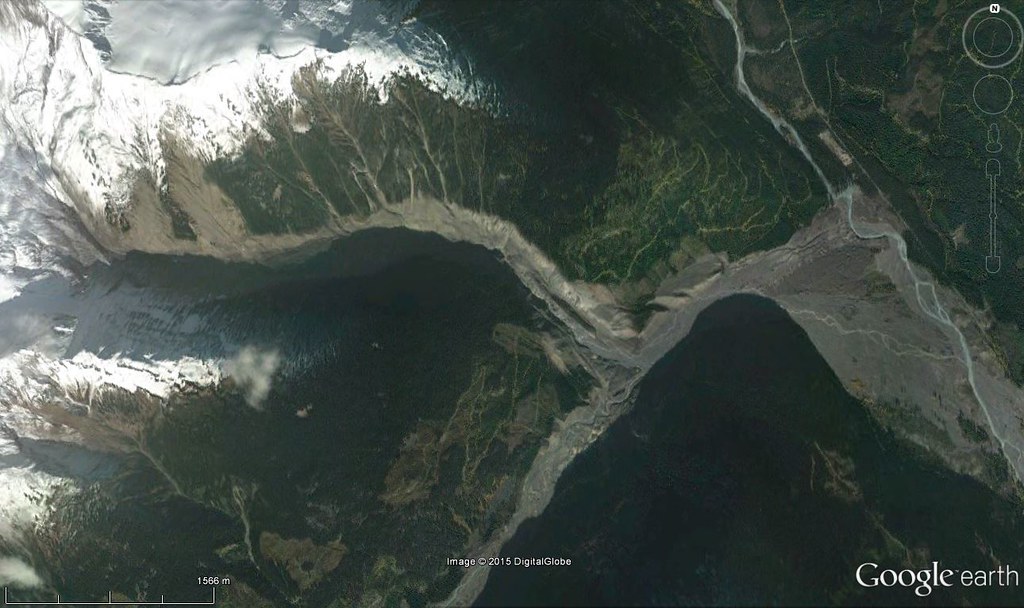
Meager landslide, British Columbia, Canada.
Mount Meager is a volcanic massif in the Pacific Ranges of the Coast Mountains in southwestern BC, part of the Cascade Volcanic Arc.
Scientists have argued that Mount Meager, made of altered volcanic rock which breaks apart easily, is the most unstable mountain massif in Canada and may also be its most active landslide area. More than 25 landslides have occurred at Mount Meager in the last 8,000 years. Debris flows, mainly from Mount Meager, have also filled Meager Creek valley to a depth of 250 m.
2010 landslide (from wikipedia): "On August 6, 2010 a massive lahar cascaded down from Capricorn Glacier at a speed of 30 m (98 ft) per second. Experts initially estimated that the volume of debris totaled 40,000,000 m3 (1.4×10⁹ cu ft), which would make it the second largest landslide on record in Canadian history, behind the 1965 Hope Slide that removed 47,000,000 m3 (1.7×10⁹ cu ft) of rock from Johnson Peak. However, the Meager landslide was later estimated to be more than 48,500,000 m3 (1.71×10⁹ cu ft), which would make it the largest of all time in Canada.
The 2010 landslide at Mount Meager was 300 m (980 ft) wide and 2 km (1.2 mi) long, creating a dam across Meager Creek and the Lillooet River. This created a lake just upstream. Early concerns that the dam might collapse and flood the Lillooet River valley ended a day later, when part of the dam ruptured and slowly released the accumulated water. An evacuation alert was rescinded, and nearly 1,500 residents were allowed to return to their homes on the weekend after the landslide occurred. No injuries were reported."
Ole.. I thought your hint about how easy it was would help others, but it looks like it did not.
ReplyDeleteYour turn for 507.
Andrew
I will get the new WoGE up tomorrow.
ReplyDeleteI found it through guesswork and reasoning: It was clearly a very large landslide, from a snow-covered mountain with drainage going northeast then southeast. The distribution of roads and other human activity pointed to North America, and the relative "crookedness" of the roads pointed away from the USA. Lack of a valley glacier took me away from the northernmost areas, and a bit of luck took me right to the correct spot even if the slide deposit itself wasn't visible at the wide view I used for searching. There are two areas with similar drainage patterns, but the other one had the wrong type of rocks so the mountains look very different. :)
And WoGE #507 is up: http://overburdenblog.blogspot.no/2015/09/where-on-google-earth-507.html
ReplyDelete